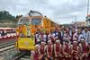


INDIA: This month is expected to see the start of tracklaying on the short but significant Sevoke – Rangpo line, which will be the first railway to serve the isolated northeastern state of Sikkim.
Citing strategic and military concerns, India has been investing heavily in recent decades to reinforce the rail network across its eight northeastern states of Arunachal Pradesh, Assam, Manipur, Meghalaya, Mizoram, Nagaland, Tripura and Sikkim. This region of more than 250 000 km2 has suffered from geo-political isolation since Partition in 1947, which left it connected to the rest of India by the narrow 21 km wide Siliguri corridor, nicknamed the ‘Chicken’s Neck’. More than 99% of its borders are international, the region being bounded China, Bhutan, Myanmar and Bangladesh.
Noting the rapid expansion of China’s rail network, India has sought to reinforce the rail and road links to its border region, despite the challenging terrain. Some years ago, the government embarked on a multi-phase connectivity project to connect the capitals of all eight northeastern states to the national railway network.
Prior to partition, Assam and Tripura were served by railways through what is now Bangladesh. After the links were severed, the rail distance from Tripura to the port of Kolkata port increased from 400 km to 1 645 km route via the ‘Chicken’s Neck’. Improved connectivity was seen as essential for both socio-economic and security reasons, but it is also expected to encourage tourism.
Capital rail links
A primary objective of the regional rail vision was ‘uni-gauge connectivity’, which triggered the conversion to 1 676mm gauge of much of the Northeast Frontier Railway network that had mostly been developed as metre gauge. Other goals included capacity to accommodate future traffic growth, extension of the network to unserved areas, and improved rail connectivity with neighbouring countries.
The state capitals of Tripura, Assam and Arunachal Pradesh were already rail connected, and new line projects were launched to serve three more. These included an 82 km line from Dimapur to Kokima, the capital of Nagaland; the 22 km Teteliya – Byrnihat line, which would serve the Meghalaya capital at Shillong; and the 51 km Bairabi – Sairang line serving Aizawl, the capital of Mizoram, as well as the 111 km Jiribam – Imphal line to improve connectivity in Manipur.
This left Sikkim as the last state to be connected, which will be achieved by the completion of the Sevoke – Rangpo railway and its second-phase extension to the state capital Gangtok.
Strategic importance
Notwithstanding its small size (7 100 km2 and 600 000 population), Sikkim is of great political and strategic importance for India because of its location in the eastern Himalayas. It is bordered by Nepal to the west, by Tibet to the north and by Bhutan to the southeast.
Historically, Sikkim’s major rail gateways were Siliguri and New Jalpaiguri stations, in West Bengal. National Highway 10 provides connectivity from there to Gangtok, but it is frequently disrupted during the monsoon season. Completion of the Sevoke – Rangpo Link will significantly reduce reliance on road transport, bringing the railhead to within 38 km of the capital and 21 km from Sikkim’s sole airport at Pakyong.
Challenging terrain
Rail connectivity is expected to streamline Sikkim’s transport logistics, reduce transit times, and enhance the overall tourism experience for visitors.
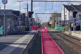
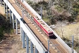
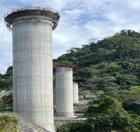
The branch will diverge from IR’s New Jalpaiguri – Alipurduar – Samuktala Road line at Sevoke, near Siliguri in the Darjeeling district of West Bengal, and run to Rangpo in Sikkim’s Pakyong district. There will be five stations, at Riyang, Teesta Bazar, Melli, and Rangpo. Of these, Teesta Bazar is described as India’s first entirely underground main line railway station (as opposed to a metro).
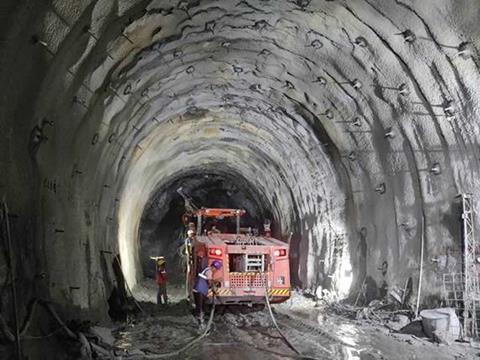
When first approved 15 years ago, the first phase was expected to be 53 km long. Alignment changes have reduced the final length to 45 km, of which just 3·5 km is in Sikkim and the rest in West Bengal. No less than 86% of the route will run in tunnel, with 14 bores totalling 38·5 km — the longest single tunnel being 5 270 m. There will also be 28 bridges, of which 13 are designated as major structures. The line has been designed for a 25 tonne axleload and a maximum speed of 110 km/h. The steepest gradient will be 1·25%.
Running through the foothills of the Kanchenjunga mountain range, the railway must span the deep gorges and valleys of the picturesque Teesta and Rangpo rivers, which is expected to offer passengers a scenic journey.
Environmental considerations
As well as the mountain range and river gorges, the railway line’s passes through the Mahananda Wildlife Sanctuary, home to various species of flora and fauna and a protected area known for its rich and diverse ecosystem. It traverses the Darjeeling, Kurseong and Kalimpong forests in West Bengal, as well as Sikkim’s Pakyong forest. These wooded areas are ecologically significant, and play a crucial role in maintaining the region’s biodiversity as well as providing habitat for wildlife.
The Teesta and Rangpo rivers are vital water bodies in the region, underscoring the need for environmental conservation and the protection of water resources.
Careful planning was required to minimise any ecological impact from construction of the railway, highlighting the intricate balance between development and environmental conservation and the importance of sustainable infrastructure development in an environmentally sensitive region.
Final clearance for the new line was not received from the government’s Environment & Forest Ministry until 2013. To obtain approval, Indian Railways proposed in February 2013 to install elephant sensors along the section of the line which passes through the Mahananda wildlife sanctuary or to run trains at a speed of only 20 km/h in the forest area, so that they would be able to stop the when an elephant was sighted close to the track. The Supreme Court of India approved the project in February 2016 with strict guidelines set out by the National Wildlife Board in June 2015, but ordered operation at restricted speeds and the provision of wireless animal tracking sensors. Tunnel excavation was only permitted during daytime.
Time and cost over-runs
A foundation stone for the railway was laid by the Vice President of India as long ago as October 2009, and the construction contract was awarded to IR subsidiary Ircon International.
About a year ago, Railway Minister Ashwini Vaishnaw noted that completion of the line had been delayed by the formidable geological challenges — complicated terrain, poor strata of rocks — as well as the delays in obtaining the necessary environment clearances. This had been further exacerbated by the Covid-19 pandemic. Nevertheless, the project authorities have scheduled the start of tracklaying for early June, and the line is now expected to be completed by ‘about’ August 2025.
Cost of the line was initially estimated at Rs13·4bn in 2008, but that had increased to Rs40·8bn by 2015. According to Ircon officials, current estimates put the final bill at around Rs121·3bn.
Meanwhile, as work on the first phase nears completion, planning is underway for two further extensions. A second phase would take the line from Rangpo to Gangtok via Singthan and Ranipool, and a third phase would run from there to Nathula on the border in eastern Sikkim. Nestled amidst the breathtaking landscapes of the Himalayas, Nathula is seen as holding the key to transforming Sikkim’s tourism potential. By enhancing accessibility, reducing travel barriers, and providing seamless connectivity, the railway is poised to elevate Sikkim’s position as a premier tourist destination.
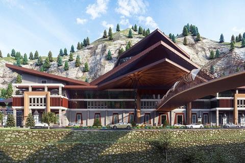
The design of Rangpo station has been inspired by Sikkim’s rich culture, heritage and vernacular architecture.